 |
| The bothy of Luib Chonnal from the west |
In late 2018, we hatched a plan for another attempt to visit Luib Chonnal and pencilled in a date in February 2019. Keeping an eye on the weather, we kept other options open, such as Glen Buck or Staoineag (direct access off the A82) in case of a repeat of the 2016 snows. To our fortune (depending on the outlook), climate change or Global Warming had a severe effect on the Scottish winter of 18/19 so that February was recorded as the warmest month in the UK since records began. There was to be no snow risk to our visit.
Of course, there still had to be some precipitation to endure, and when we parked up at the Brae Roy road end, it was chucking it down. The windscreen wipers on at a steady rate. It was 2pm. After a few minutes of discussion, and eradicating the Plan D of heading back down the glen to a local (dry) hostelry to watch France play Scotland in the Six Nations, we donned boots and full waterproofs to set off.
The start of the walk passes the deserted Brae Roy Lodge, nothing happening other than a generator making a racket in an outbuilding. Thence onto a decent land-rover track over the Turret Bridge, and gradually east.
 |
| Turret Bridge in the rain |
A couple of hundred metres short of the bothy, the LR track turned south towards the river, and a rough footpath headed directly across some very boggy ground. To the south, across the river the White Falls came into view looking very impressive. Beyond them, the ground rose gently up into the clouds of the Meagaidh massif.
 |
| The White Falls |
 |
| The sun sets in the west, down Glenroy between showers. |
"How long do you think it will take you?" he said, presumably wondering how long he'd be waiting at the car.
After a quick glance of the map I made a guess at least 2.5hours, but depending on the ground conditions it could be much more. We bade goodbye and I set off at a trot up the ATV track to the north that ran parallel to the Allt Chonnal. The path crossed the river at a new bridge after 1km, so I continued over tougher ground. Eventually it was time to leave the river and start the cross-country ascent towards the lower Carn Dearg.
Unfortunately the ground here was the peat-hag wobbling morass that I'd heard of in the book. At one point I was faced with a 5metre wide, 100m long water filled gap of slop. Eventually after 60minutes I reached the summit cairn in a strong westerly wind. I grabbed a quick photo and spied my next summit to the north.
 |
| View down Glen Roy from Carn Dearg |
During the descent, I was able to see the Teanga Mor which extends west from the summit of the northern Carn Dearg and was described by the Walkhighlands with "There are some extensive areas of peat hags to cross on the long, steady pull that curves round towards the summit of the northern Carn Dearg". It was clear these peat-hags were confined to the highest part of the shoulder. On the southern slopes it appeared featureless and grassy. I made a note to head that way on the descent.
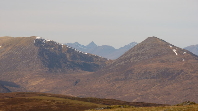
Dropping 200m into the bealach was unfortunate but necessary to continue to the second summit, and thirty minutes after the first Corbett, I was on the summit of the 2nd Carn Dearg of the day. The wind was keen here so I didn't hang around long, just enough to stuff a flapjack down my throat and a quick scan of the horizon. There were good views out to the west, Knoydart and Kintail prominent, but east was non-descript.
 |
| West from Carn Dearg(2) between Ben Tee and Sron a Choire Garbh to Knoydart - guess the peak? |
I crossed a wooden Argocat bridge over the Allt Eachach and joined a rough ATV track that headed south towards Braeroy. This wee glen felt very remote, but there were lots of ruined shielings and remnants of houses dotted about. It would have been a lovely place to live in its time.
I hit the tarmac and kept jogging, reaching the car with the waiting old friend after 3hours from the bothy.
No comments:
Post a Comment